Hiking Route 6. Valsequillo - Las Vegas
 Starting point:
Valsequillo Altitude: 550 m Destination:
Las Vegas Altitude: 612 m
Total Distance: 1890 m
Time to cover the Route: 50minutes
Direction of the Route: NE-SW
Maximum Difference in Altitude: 141 m
Difficulty rating: Low

![]() This is a route that formerly connected two traditional agricultural valleys, crossed by the San Miguel and Los Mocanes ravines. The surface is made up of material from the collapse of the Tenteniguada erosive caldera. The route runs for a distance of 1865 metres in a NE-SW direction and can be covered in about 50 minutes.
This is a route that formerly connected two traditional agricultural valleys, crossed by the San Miguel and Los Mocanes ravines. The surface is made up of material from the collapse of the Tenteniguada erosive caldera. The route runs for a distance of 1865 metres in a NE-SW direction and can be covered in about 50 minutes.
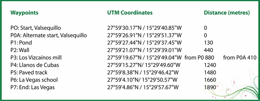
We shall start the route along a short, 130 m stretch of tarmac opposite Calvario, PO Start Valsequillo. We continue down the road to the E until we come to the beginning of a footpath after crossing the town of Chinchemy, where we will see crops of the famous Valsequillo strawberries.
The footpath starts to the right of a large pond at point: P1 Pond. The route leads down the side of the San Miguel ravine, where we shall pass a closed-up cave. There is an abundance of rock-dwelling species that are endemic to the Canary Islands, such as lavender (Lavandula canariensis), Canary sage (Salvia canariensis), mato de risco (Allagopappus dichotomus) or bejeque (Aeonium percarneum), accompanied by other species such as broom or verodes.
The footpath winds downhill for about 310 metres to the bed of the San Miguel ravine. Here, we shall find a wall built to retain the water that flows down the course with a view to facilitating infiltration to improve the water table, point: P2 Wall.
At this point, there is an interesting alternative that will take us to an archaeological site of great interest. Heading east through crops and pastures, we shall come to a gentle slope that will take us to El Roque. This is a rocky fortress at a distance of 900 m from P2, where there is a pre-Hispanic troglodyte settlement (Image F3). There are many caves on the north face of the ravine; in fact, the neighbourhood of Los Llanetes originated through the use of the native caves as homes or shelters.
Back on the main route towards Las Vegas, or directly if you did not take the optional section, we shall continue making our way up the channel. The vegetation now reflects the greater ambient humidity and several species alternate, such as white tajinaste (Echium decaisnei), blue tajintaste (Echium callithyrsum) endemic to Gran Canaria, venenilla (Bryonia verrucosa), May blossom (Pericallis webbii), verodes (Kleinia nerifolia), tabaiba (Euphorbia regis-jubae) endemic to the Canary Islands, dock (Rumex Lunaria).
If we move on about 440 metres, we shall find the point: P3 Vizcaínos Mill on the right, which is located in the bed of the ravine, and shows how productive uses have changed, as it is no longer used for grinding the grain and remains as a testimony of former cereal use.
Due to these changes, many of the old rural roads disappeared or were almost obliterated, and the footpath we shall now take to make our way up the left-hand bank has been recovered for hiking after losing its original use. We shall climb 360 metres to point: P4 Llanos de Cuba, where we shall see crops and the Los Llanos de Cuba well at the end of the footpath.
Here, we can enjoy a landscape of buildings of ethnographic value, embedded between crops. It is not very difficult to find extremely important vertebrate species endemic to the island, such as the Canary Island lizard or the Gran Canaria skink, which has two subspecies, as well as some birds, such as the Canary Island chiff-chaff (Phylloscopus collybita canariensis), exclusive of the islands or the Canary Island blue tit (Parus caeruleus teneriffae), a subspecies endemic to Gran Canaria of the four that exist in the Canary Islands.
After about 240 m along a footpath marked by a stone wall, next to some crops, we shall reach point: P5 paved track.
The crops gradually give way to houses and after walking 180 m we shall reach point: P6 Las Vegas school, where we shall turn right to make our way up a rather steep hill and, after 230 m, reach the end of the route at point: P7 End Las Vegas, at the foot of the main road between Telde and San Mateo, GC-41. We are in a neighbourhood where quality local cuisine will help us regain strength and where artisans offer products based on the best of our traditions.
Alternative initial section
Instead leave from Chinchemy, we can do so from La Silla Street and walk down to the cross-roads at point P3 opposite the Los Vizcainos Mill.
This option has the added attraction of enjoying the views of the upper section of San Miguel ravine and of the many cave houses that dot this part of the slope. It also enables us to enjoy a closer view of the mill.
On this route, the distance to point 3 is considerably shorter, about 410 m compared with 880 m, so the total distance is reduced to 1420 m against 1890 m for the full route. We can also use it as the final part of the route back to Valsequillo from Las Vegas. In this case, the round route would be 3060 m.
Hiking Route 7. Valsequillo - San Roque via Corona del Montañón
 Starting point:
Valsequillo Altitude: 580 m
Destination:
San Roque Altitude: 330 m
Total Distance: 9140 m
Time to cover the Route: 3h. 30’
Direction of the Route: SE-NW/W-E
Maximum Difference in Altitude: 621 m
Difficulty rating: Low

![]() This route is renowned for its ethnographic values related to traditional agricultural and livestock uses. In addition, the first section is part of the annual pilgrimage to Teror, to celebrate the festivities of the Gran Canaria patron, the Virgen del Pino.
This route is renowned for its ethnographic values related to traditional agricultural and livestock uses. In addition, the first section is part of the annual pilgrimage to Teror, to celebrate the festivities of the Gran Canaria patron, the Virgen del Pino.
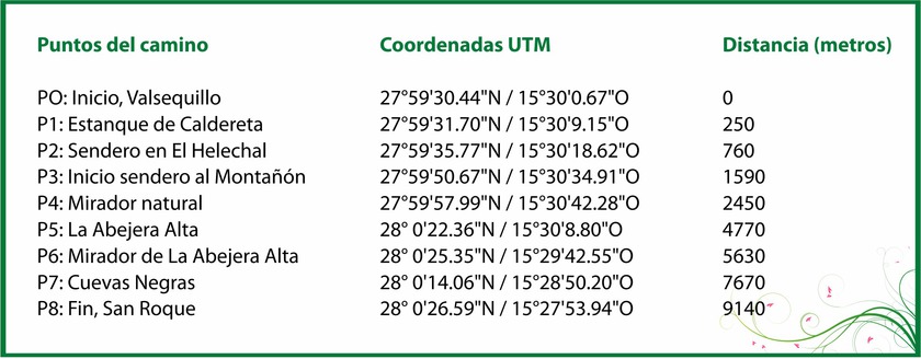
The route commences at a viewpoint in Sol Street, at point P0 Start Valsequillo. From here, we can see the San Miguel ravine, where the Colmenar Barracks, built in 1530, are located. It has been declared a Site of Cultural Interest and a number of buildings linked to military life have been preserved. If we look further up, we shall see San Miguel Bridge and the mill of the Pérez, from the eighteenth century, the oldest construction of this type in Valsequillo. Beyond these heritage sites, the view encompasses the Tenteniguada basin, of exceptional landscape and natural interest.
We shall continue West on the paved road that climbs to the Helechal viewpoint. The slope, which is not too steep, skirts the ravine. We shall pass some houses on the left, cross an intersection and continue in the same direction for about 250 m until we reach point: P1 Caldereta pond.
We shall continue along the side of the road, which turns East, until, after 490 m it will bring us to the beginning of a steep footpath on the left; point: P2 El Helechal footpath
The footpath takes us up the southern slope of Helechal Mountain for about 250 m with the Caldereta (small crater) on our left. These are two important geological features. At the top of Helechal Mountain, the viewpoint gives us a panoramic view of almost all Valsequillo. This mountain has preserved a religious meaning over the ages. In aboriginal times, it was an Almogaren - place of worship of the ancient Canary Island people. Its religious significance has been preserved by the construction of a cross; the one we can see is the third since the first one was built at the dawn of Christian occupation.
Previously, on the roadside, we shall see rock-dwelling vegetation of interest, such as a rock rose species (Cistus monspeliensis) native to the Canary Islands.
Walking along the paved road, while crossing El Helechal, we shall come across traces of traditional agriculture, such as some “alpendres” (shelters), pond-caves and some well-preserved houses. We shall now come to a hill heading north, which we shall follow, after about 830 m from P2, until we reach point: P3 Footpath to Montañón.
This footpath is still used to go to San Mateo and on pilgrimage to Teror. The ancient nature of the road can be seen at our feet: a well-preserved cobbled path bears witness to its historical usage. The rock vegetation takes advantage of the moisture at middle altitudes to grow.
At the summit of the mountain, at an altitude of 860 metres, we reach a natural viewpoint where the view encompasses Valsequillo and parts of San Mateo and Santa Brigida at point: P4 Natural viewpoint.
The route skirts the head of the San Roque Ravine where we will find a fork in the track and then another intersection heading NE. The landscape displays how the environment has been adapted to traditional mid-altitude agriculture and livestock activities, which still survives in this area, with terraces, channelled courses, water springs, and alpendre-caves.
Once we have passed the fork, we shall continue along a dirt track until we come to a sharp bend to the right and a footpath. From there, we shall head to the area known as Abejera Alta after walking over 2300 m, to point: P5 Abejera Alta.
The deft hands of country people have left their mark on this landscape of important ethnographic value, where the terrain is modelled into terraces for cultivation - many of which have been abandoned - with stone walls, alpendres and hydraulic works, such as a water mine and the channelling of the ravine, where pear and fig trees thrive.
We shall keep to this old transhumance route for about 860 metres as far as Abejera Alta, at point: P6 Abejera Alta viewpoint. A road much used by shepherds connects us to the neighbourhood of Los Lomitos de Correa. Looking south, the view over Valsequillo is spectacular, while, to the north we can see the mountains as far as the ocean. Looking down into the ravine, we shall see a building that was once an old school. At this point, hikers suffering from vertigo should be cautious.
This is a place where we may be able to observe the graceful flight of the buzzard (Buteo buteo insularum), a sample of natural values.
After passing the mountain, we shall begin the descent to the east, between rock formations where there are endemic species, such as “bejeque rosado” (Aeonium percarneum). On the way down, we shall come across more alpendre-caves.
After more than 2000 metres heading East, we shall reach a paved road in an agricultural area at point: P7 Cuevas Negras. We shall make our way across this area of troglodyte habitat that gives its name to the surrounding district. Then we shall cross a hamlet and head towards Cuevas Blancas.
Walking down the main road, enjoying the beauty of the Cuevas Blancas ravine, we will approach the end of the route at the spectacular San Roque Palm Grove, one of the best preserved in Gran Canaria and with the highest genetic purity. Together with Canary Island date palms (Phoenix canariensis), we will see a stand of wild olive trees (Olea europaea cerasiformis) at the lowest levels of this thermophilic environment.
We will make our way down the left-hand side of a small ravine to a paved road that connects with the main road that leads East, after walking about 1600 m from P7, to the neighbourhood of San Roque, point: P8 End San Roque.
Hiking Route 9. Los Marteles Caldera - Tenteniguada via Los Alfaques. Blue Tajinaste Routes
 Los Marteles Caldera Altitude: 1529 m
Destination:
Tenteniguada Altitude: 767 m
Total Distance: 5880 m
Time to cover the Route: 2hr. 15’
Direction of the route: SW-NE
Net Difference in Altitude: 762 m
Difficulty rating: Low

![]() The route runs SW-NE and is classified as a low difficulty itinerary although it can be slippery in the rainy season. The route is of great ethnographic value, given its use for transhumance, and is located in an area of exceptional natural and landscape interest; the Los Marteles Special Nature Reserve.
The route runs SW-NE and is classified as a low difficulty itinerary although it can be slippery in the rainy season. The route is of great ethnographic value, given its use for transhumance, and is located in an area of exceptional natural and landscape interest; the Los Marteles Special Nature Reserve.
The route begins next to the GC-130 road, point: P0 Start Los Marteles Caldera, where opposite the route we can find one of the most significant geological elements in Gran Canaria: Los Marteles Caldera, the base of which is used for agriculture.
The first section passes north of the caldera along a forest track on the right, (Image F3) through a reforestation pine forest with epiphytic lichens hanging from the trees, proof of the moisture and low temperatures of this district, which sits on lava formations from the Recent Cycle.
Once we exit the pine forest, we shall come to an area known as Lomo del Salviar, where we shall find some buildings, one of which contains a well - one of the many that exist in the Reserve - as water is one of the most important resources in the area.
In this section, where the ground is based on basanitic-nepheline flows from the Post Roque Cycle, there are abandoned cultivation terraces where, alternating with grassland, we shall find broom, with some Canary Island flatpod (Adenocarpus foliolosus) and typical species from this summit area, such as species of the Micromeria genus, to which the different types of thyme belong. There is also summit marguerite daisy (Argyranthemum Adauctum canariense), a subspecies endemic to Gran Canaria and wild oats (Avena canariensis), an endemic grass species to the islands. From this section on and in the next three sections, we shall find one of the most important species that is unique to this area, the Tenteniguada thistle (Onopordum carduelinum), a species listed in the Red Book of endangered species in the Canary Islands and also listed as endangered by the IUCN (International Union for the Conservation of Nature). The wind has helped the goldfinch (Carduelius carduelius prava), whose song is very special, to extend to this area together with the assistance of the bounty of seeds.
After about 960 metres, we shall reach a bend to the right and the beginning of a footpath at point: P1 Beginning of the footpath that will lead us in a Northeast direction, on the left. This part of the route (Image F1) that leads through an area of yellow broom (Teline microphylla) alternating with blue tajinaste (Echium callithyrsum) leads to an area known as Morro del Aguililla, a name given to this place that refers to a bird of prey (Buteo buteo insularum), a subspecies of the Canary Islands, which is very conspicuous by its size and beauty and can be seen along most of the route. At the base of this hill are some caves of ethnographic value that were used for livestock transhumance and we may also see some demolished “alpendres” on our way down to the forest track.
In this area, we will be able to enjoy a very nice panoramic view of the Tenteniguada basin and of Los Roques and Umbria Ravine.
At the base of Morro de la Aguililla, after walking down for about 340 m, we will take the track again at point: P2 Dirt forest track, along a rather slippery area of lapilli from the Early Pleistocene.
After about 540 m, we shall come to the footpath that leads down to the north on the left hand side of the track, point: P3 Back to the footpath.
The first part of this section passes along basanitic-nephiline flows from the cycle mentioned in the previous section in the area leading to Degollada de Los Cardos, a name that refers to the amount of thistles (Cardos de Tenteniguada) in the district. In this area we will get a spectacular view of the entire municipality of Valsequillo and of much of the Tenteniguada semi-basin, overlooking the inside of Umbría Ravine, whose name refers to the weather in this area.
After about 830 m, we shall reach point: P4 Natural viewpoint. This is an ideal place for observing geological phenomena, such as the “roques” in the Tenteniguada semi-basin, (Image F2), the erosion of the basin and the formations protruding from the ground from the Post Roque Nublo Cycle. The route runs through a spectacular landscape known as the Mocanal Massif, which geomorphologically consists of high and abrupt formations between the Tenteniguada sub-basin and Los Cernícalos, with steep slopes and isolated topographically.
The area known as La Mesa features pasturelands where we can find many species of invertebrates and birds, such as the corn bunting (Miliaria calandra) or the canary (Serinus canaria), endemic to the Macaronesian Region.
After continuing along a flat section for about 530 m, we shall reach point: P5 Descent to Los Alfaques where we shall begin to zigzag our way down part of the steeper sections of the route (Image F4) while enjoying a spectacular view of the part of the municipality of Valsequillo that gives its name to the route.
Here we shall find a beautiful landscape of flora and fauna including the presence of such species as yellow broom, blue tajinaste, morgallana (Ranunculus cortusifolius), a Macaronesian endemism, cerrajera (Sonchus acaulis), present all along the route, and broom (Chamaecytisus proliferus), the latter two species endemic to the Canary Islands.
As we go down this footpath of exceptional ethnographic value, which preserves its ancient layout, we shall also find some wild olive groves (Olea europea cerasiformis), a subspecies that is endemic to the Canary Islands.
At the end of this footpath, we shall come to agricultural areas, where we shall find almond trees (Prunus amygdalus), alternating with natural areas until, after adding just over 2 km to our route due to the winding nature of the footpath, we shall come to the end point: P6 End of the footpath, where there is a small road next to some houses that will eventually connect with a paved road with a well on the left.
We shall follow the road past the Tenteniguada Cemetery, up to the bus stop which is located next to the main Telde-San Mateo road, GC-41, where, after about 660 metres we come to the end of the route at point: P7 End, Tenteniguada.
Hiking Route 8. Rincón de Tenteniguada - Roque la Vela - Rincón de Tenteniguada, Route of the Ravines. Blue Tajinaste Routes
 Starting point:
Rincón de Tenteniguada Altitude: 970 m
Destination:
Rincón de Tenteniguada Altitude: 970 m
Total Distance: 2750 m
Time to cover the Route: 1hr. 15’
Direction of the route: NE-SW/W-E/S-N
Maximum difference in altitude: 205 m
Difficulty rating: Low

![]() Most of this circular route leads through the protected areas of the Los Marteles Special Nature Reserve. The landscape values are outstanding and, together with the geological formations and rich biodiversity we shall come across, it is a route of exceptional interest from start to end, at Rincón del Tenteniguada after passing through Lomito del Tafetal and Coruña Ravine.
Most of this circular route leads through the protected areas of the Los Marteles Special Nature Reserve. The landscape values are outstanding and, together with the geological formations and rich biodiversity we shall come across, it is a route of exceptional interest from start to end, at Rincón del Tenteniguada after passing through Lomito del Tafetal and Coruña Ravine.
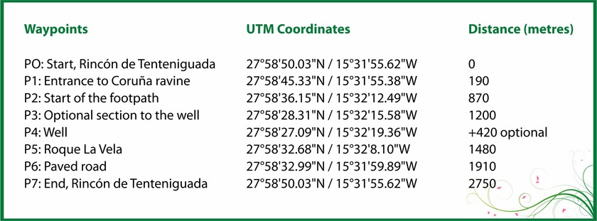
The route begins with a 190 metre section: P0 Start Rincón de Tenteniguada, in Rincón Square. We shall cross the town of Rincón on a paved road towards the SE and then turn right to make our way up to a left-hand bend. Here we will find the beginning of a cement track on the right of Barrancos Street: P1 Entrance to Coruña ravine. This cement track leads through agricultural areas to the left-hand bank of Coruña Ravine, where the damp environment at this middle altitude and the fertile soil encourage the growth of a variety of plants. The first part of the route leads us to some cave houses and shelter-caves “alpendres” dedicated to traditional uses.
Roque Jincao will be overlooking us as we come to an intersection on the cement track where there is a footpath that comes from Cuevas Blancas Dam. We will come to a pond on our way and, a little further on, a dirt track that will take us into an area of laurel bushes. There will be species that are typical of this environment, such as Canary figwort (Scrophularia callantha), endemic to Gran Canaria and found throughout Coruña Ravine, and a wide range of species, such as blue tajinaste (Echium callythirsum), tree sorrel (Rumex Lunaria), summit marguerite daisy “magarza” (Argyranthemum adauctum) and giant buttercup “morgallana” (Ranunculus cortusifolius).
After about 870 meters on the road and track, we will come to point: P2 Start of the footpath.
Geology now becomes the protagonist as we come to hillside deposits from the Recent Cycle colonized by plant species that also require high levels of humidity, including may flower “flor de mayo” (Pericallis webbii), “ortigón” (Urtica morifolia ) and canry bell flower “bicácaro” (Canarina Canariensis).
The footpath makes its way upstream until, after about 240 m, we come to point: P3 Optional section to the well. Here, we may take an alternative route for about 210 metres before crossing the ravine. It leads E-W and will take us to a well, point: P4 Well. At the well, which is in use and reminds us of the abundant water resources in this area, there are fruit trees interspersed with native vegetation, an ideal habitat for a rich variety of fauna.
Back at point P3, we shall continue our route in a SW direction up a hill that is colonised by a grove of broom (Chamaecytisus proliferus), a type of bush present almost along the entire route, some of which are of considerable size and are hanging with epiphytic lichens that draw the moisture left by the trade winds in this area.
We shall walk down the basaltic deposits on the hill, home to rock-growing vegetation, including different types of succulents, such as a Gran Canaria endemism, stalked aeonium “oreja de abad” (Aeonium undulatum) that turns the slopes bright yellow from April onwards.
At this point we shall also find common species, from the same family, such as Aichryson laxum, Aeonium percarneum, Aeonium simsii, Aeonium spathulatum or Greenovia aurea.
Further up the southern end of the ravine, we shall come to the base of Roque del Pino after covering another 280 metres, point: P5 Roque de la Vela. This is a whimsical natural structure that has survived the effects of erosion to become a viewpoint overlooking the Tenteniguada semi-basin and Roque Grande, as well as the entire municipality of Valsequillo.
After the ascent comes the descent along the southern face of Lomito Tafetal, heading NE. New plant species will become noticeable on the route and accompany us, such as ginat fennel “cañaheja” (Ferula linkii), a Canary Island endemism.
The descent ends in a typical rural mid-altitude environment, where homes, “alpendres” and caves appear alternating with vegetable gardens. After a descent of 430 metres, with some very steep sections, we shall reach point: P6 Paved road.
This section begins at the foot of a paved road heading NE along the highest area of Rincón de Tenteniguada. This landscape is dotted with agricultural plots, which reminds us of the agricultural history of this district, with houses that are over a century old and cave houses and cave-shelters “alpendres” that are still in use, highlighting the popular traditions that are still alive in this area.
We shall carry on for just over 800 m to the point where the route comes to an end, which was also the place from where we set off, at point P7 End, Rincón de Tenteniguada.
Inspiration for experiences on Gran Canaria
Taste your way to your local favorite rum or get an artistic ’kick’ in the museum galleries. Have a look into the caves where there is still activity or visit Europe's only coffee plantation in mountains on Gran Canaria. Yes - Gran Canaria's mountainous hinterland, away from the turistzone and beach, offers adventures for several day trips. Here at Canariainfo.com you can find plenty of inspiration and we would like to be your guide
 Teror
Teror The blessed Virgin's capital
On the northern part of the island, home to a peaceful Catholic madonna "La Virgen del Pino" in the church "Basilica de Nuestra Señora del Pino ". Her museum has a large collection of gifts from her admirers, ranging from swords and military orders to toy cars, letters, jewelry, watches and a UN beret.
A beautiful city with fine, antique mansions in the traditional Canarian style with wooden balconies covered by bricks and house corners, doors or windows framed by raw basalt stone from Teror, one of Gran Canaria's most beautiful cities.
Many local events are associated with Teror and is certainly worth a visit.
Transport: Bus 216 from Las Palmas
 Arucas
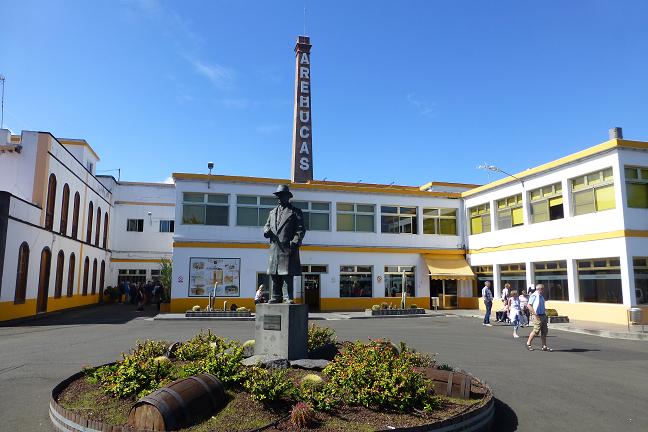
The city with one of the largest rum factory "Fabrica de Ron Arehucas"
In the town of Arucas is the "Fabrica de Ron Arehucas", one of Europe's largest romfactorys, producing a total of 16 different drinks like rom liqueurs flavored wit banana, coffee, chocolate or lemon.
Taste your way to your favorite rom. Yes, all the goodies are free to be tasted before the exhilaration goes shopping area in the factory store.
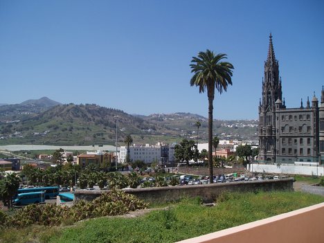 At the other end of town, you can admire the huge, neo-gothic church, "Iglesia de San Juan Bautista" that looks like a fascinating temple from a fantasy tale and has clear similarities with Gaudí-like church, La Sagrada Familia in Barcelona.
Transport: Bus 205 from Las Palmas
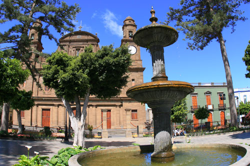 Gáldar
Gran Canarias little mecca for painting
The Canary Islands' most famous cave paintings of red, white and black triangles painted by the island's original inhabitants, together with the remains of a large village built of lava stones admired in Gáldars newly opened archaeological museum, "Parque Arqueológico Cueva Pintada". Gáldar is also worth a visit for its eminent art museum dedicated to the expressionist Antonio Padrón, in color choices and a technique that is reminiscent of Picasso, depicting the Canarian culture and daily life. In addition to one of the island's basic themes is the absence of rain, he describes also scenes of superstition, cockfights, fish hanging to dry on cords, and much more that is the national soul near.
 Caldera de Bandama
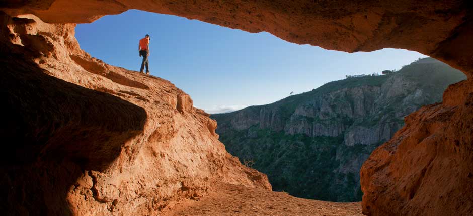
From "Grand Canyon" similar backdrop view, to a dizzying look down into the black abyss
The viewpoint "Pico de Bandama" offers panoramic view of Gran Canaria's east coast, and a look down at 200 meters deep and 1,000 diameter wide, perfectly round volcano crater Caldera de Bandama. Lava stone crunches under your feet, and a forest of cactus sprouting up of the black ground on the way down into the crater, the steep, red slopes creates a Grand Canyon-like backdrop, where every moment expecting to see John Wayne appear on the horse behind a rocky outcrop. In under an hour you can go to the bottom of the crater via the path that starts from the village about 1.5 km below the viewpoint.
Transport:Private car to the viewpoint or on a trip with canariainfo
 San Pedro
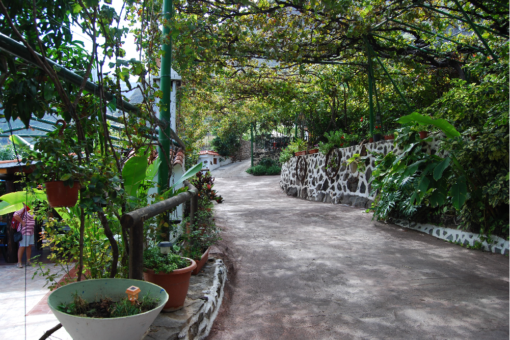
In San Pedro Valley, Europe's only coffee plantation
In this area is also the city Agaete which offers an abundance of experiences. Canaria Info offers regularly guided tour of the coffee plantation and here you get the whole experience, tastings and more. See tour information
| Oversigt hoved byerne |
|---|
| Patalavaca* |
|---|

Finca Cordal, museum and events
Museo de la Zafra, the hard wearing of tomato plants

Las Salinas De Tenefe, salt extraction of the Atlantic Ocean
Las Canteras besch, Las Palmas de Gran Canaria

Ticket distribution overview, easy and no queue.
- 1
- 2


